Understanding the UK Heatwave: Latest Weather Maps and Analysis
The Importance of Weather Maps in a Heatwave
As the UK experiences a significant heatwave, understanding its impact on daily life has become essential. Weather maps provide not only a visual representation of rising temperatures but also essential data that informs the public and authorities about possible health risks, energy consumption, and necessary precautions. The current heatwave has prompted widespread media coverage and public concern, making accurate weather mapping more crucial than ever.
Current Heatwave Overview
The UK Met Office has issued several heat alerts across various regions, projecting temperatures to soar between 30°C and 40°C in some areas this summer. These high temperatures are attributed to a shift in weather patterns, influenced by climate change and increasingly frequent warm airflows from continental Europe. Latest satellite imagery shows large regions turning from green to brown, indicating diminished vegetation and increased risk of drought.
Analysis of Weather Maps
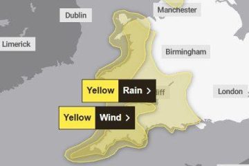
Latest weather maps published by the Met Office reveal the geographical spread of the heatwave. Southern England is expected to bear the brunt, with urban areas like London seeing particularly high temperatures. The maps illustrate predicted temperature gradients, helping to identify hotspots. Furthermore, wind patterns displayed on the maps give insight into how quickly hot air is circulating and whether relief from cooler weather is on the way.
Public Health Implications
With the extreme heat come significant public health implications. The NHS is already reporting an uptick in heat-related illnesses, suggesting heightened awareness is necessary. The government has recommended that vulnerable populations, such as the elderly and those with pre-existing health conditions, stay indoors during peak heat hours. Weather maps also play a role in directing public messaging and issuing warnings effectively.
Future Weather Forecasts
The outlook for the next week suggests that temperatures will remain elevated, although some forecasts indicate the possibility of a cooler front appearing mid-August. However, the long-term trend indicates that heatwaves are becoming more common in the UK, which fuels debates about climate policy and urban planning in adapting to such weather extremes.
Conclusion
The ongoing UK heatwave highlights the importance of accurate weather mapping for public awareness and safety. By continually monitoring temperature patterns and other meteorological data, the government and health services can better prepare, adjust their responses, and help mitigate the risks associated with this unprecedented weather phenomenon. As residents navigate the heat, keeping abreast of the latest weather maps and following public health guidance will be paramount.