Met Office Alert: Thunderstorms and Heavy Rain Sweep Across Britain
Current Weather Warning Status
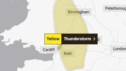
The Met Office has issued a yellow thunderstorm warning as parts of the UK face the prospect of lightning strikes and hail. The warning covers significant areas across England and Wales, having come into effect early morning and remaining active until midday.
Weather Conditions and Forecast
According to Meteorologist Ellie Glaisyer, the day has begun with very strong winds, particularly in western regions where coastal gales have been observed. Eastern areas are experiencing a brighter start with hazy sunshine, while western regions face a wetter outlook with heavy, showery rain moving northwards throughout the afternoon.
Understanding Thunderstorm Warnings
The Met Office distinguishes between rain and thunderstorm warnings based on their distinct characteristics. While rain events typically last for hours or days and may lead to river flooding, thunderstorms are characterized by shorter periods of heavy or intense rainfall, often resulting in rapid surface water flooding.
Extended Forecast
The current period is marked by unsettled conditions with low pressure dominating. This means most of the UK will experience showers or extended periods of rain. The western and northern regions are particularly prone to heavy rainfall, and there’s an ongoing risk of thunderstorms and hail, alongside possible strong winds, especially if deep areas of low pressure develop.
Safety and Preparedness
The Met Office issues these weather warnings through the National Severe Weather Warning Service when severe weather could potentially impact the UK. The warnings are color-coded (yellow, amber, or red) based on both the potential impact of the weather and the likelihood of those impacts occurring.


